Wisconsin County Map
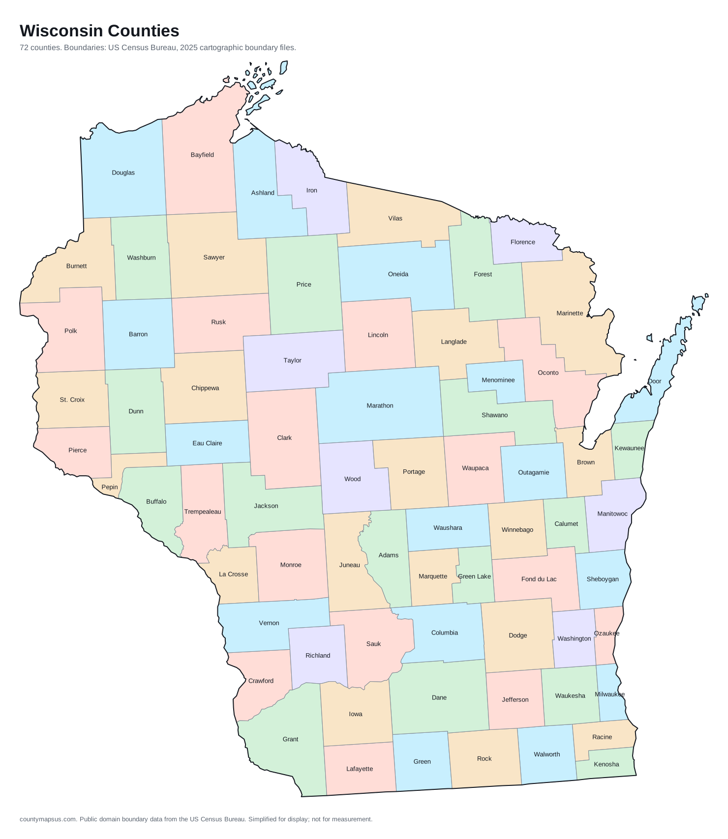
Wisconsin has 72 counties. Together they cover 54,168 sq mi of land and 5,972,787 people.
- Population
- Land area
- Density
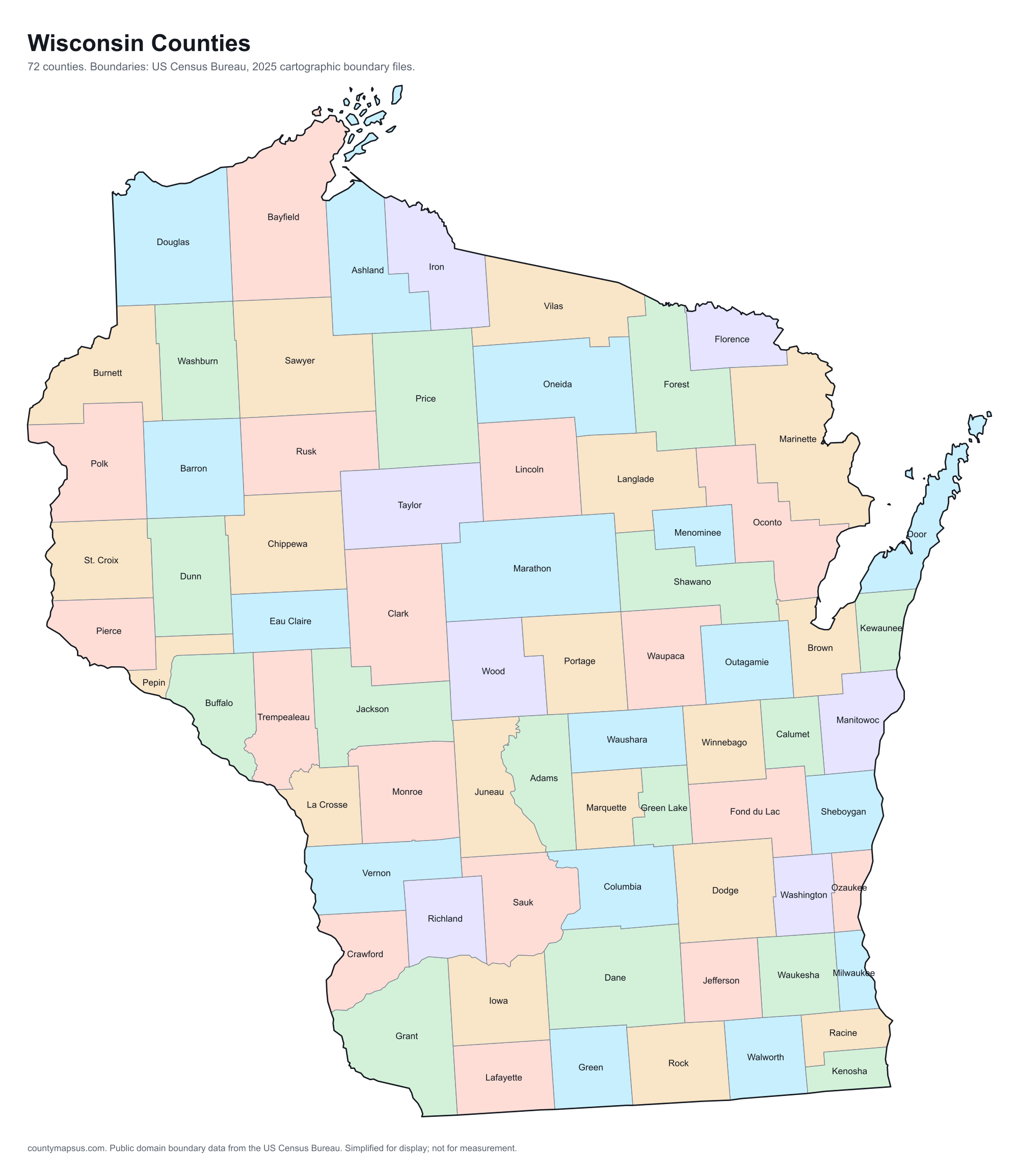
Neighbouring areas are given different colours so their shared borders read clearly. These colours carry no data.
Population from the Vintage 2025 estimates. Breaks are quintiles within Wisconsin.
People per square mile, computed from population and land area. Breaks are quintiles within Wisconsin.
Median household income, American Community Survey 2020 to 2024 five-year estimates. Breaks are quintiles within Wisconsin.
- Counties
- 72
- 19th most of the 51 states and DC
- Population
- 5,972,787
- 21st largest
- Land area
- 54,168
- square miles
- Density
- 110.3
- people per square mile, computed
Sources: US Census Bureau, Population Estimates Program, Vintage 2025 Population Estimates, released 26 March 2026; US Census Bureau, Gazetteer Files, 2025 Gazetteer Files, released 10 September 2025. Retrieved 30 August 2026.
Download this map
Free to use and redistribute. The boundaries are public-domain Census Bureau data; attribution to County Maps US is appreciated but not required.
Satellite view
Aerial imagery of Wisconsin with the state boundary drawn on top. County lines are not drawn here: at this scale they would bury the picture, and the map above already carries them.
The extremes of Wisconsin
Which is the largest county in Wisconsin? The answer depends on whether you mean area or population.
The counties, by shape
Every one, drawn to its own scale so the small ones stay recognisable. Shape alone is not a size comparison; the table below carries the areas.
- Adams
- Ashland
- Barron
- Bayfield
- Brown
- Buffalo
- Burnett
- Calumet
- Chippewa
- Clark
- Columbia
- Crawford
- Dane
- Dodge
- Door
- Douglas
- Dunn
- Eau Claire
- Florence
- Fond du Lac
- Forest
- Grant
- Green
- Green Lake
- Iowa
- Iron
- Jackson
- Jefferson
- Juneau
- Kenosha
- Kewaunee
- La Crosse
- Lafayette
- Langlade
- Lincoln
- Manitowoc
- Marathon
- Marinette
- Marquette
- Menominee
- Milwaukee
- Monroe
- Oconto
- Oneida
- Outagamie
- Ozaukee
- Pepin
- Pierce
- Polk
- Portage
- Price
- Racine
- Richland
- Rock
- Rusk
- Sauk
- Sawyer
- Shawano
- Sheboygan
- St. Croix
- Taylor
- Trempealeau
- Vernon
- Vilas
- Walworth
- Washburn
- Washington
- Waukesha
- Waupaca
- Waushara
- Winnebago
- Wood
What the map does not say
The counties of Wisconsin are nowhere near the same size. Marathon County covers 1,545 sq mi of land, 6.7 times the 232 sq mi of Pepin County. People are spread even less evenly: Milwaukee County packs 3,828 per sq mi while Iron County holds 8.1 per sq mi.
They were not drawn in one sitting either. Crawford County dates to 1818, and the boundaries were still being redrawn when Menominee County was organised in 1959, 141 years later. Founding years come from Wikidata and are worth checking against the county's own history before citing.
Water is part of the picture too: 79.7% of Milwaukee County is water, the most in the state, which is why its land area and total area disagree. And 38 of the 72 counties here share their names with counties in other states, so searching by name alone can land in the wrong place; the A to Z index lists every duplicate.
All 72 counties of Wisconsin
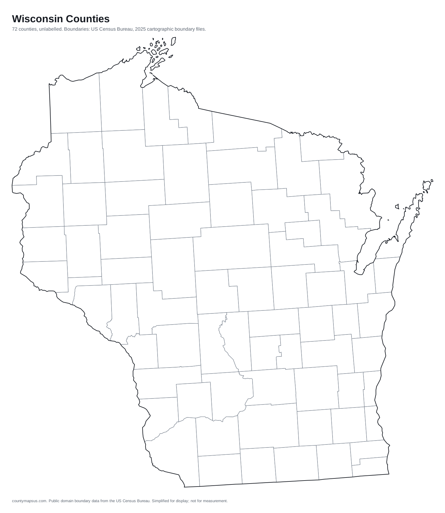
Sortable on any column. This table doubles as the text alternative to the map above: every area is a link, in alphabetical order, whether or not the map renders.
| Name | Population | Land area | Density | Median income | Seat | FIPS |
|---|---|---|---|---|---|---|
| Adams County | 21,752 | 645.6 sq mi | 33.7 per sq mi | $59,442 | Friendship | 55001 |
| Ashland County | 16,203 | 1,045 sq mi | 15.5 per sq mi | $62,462 | Ashland | 55003 |
| Barron County | 46,484 | 863.1 sq mi | 53.9 per sq mi | $65,933 | Barron | 55005 |
| Bayfield County | 16,787 | 1,478 sq mi | 11.4 per sq mi | $71,151 | Washburn | 55007 |
| Brown County | 275,803 | 530.1 sq mi | 520 per sq mi | $79,649 | Green Bay | 55009 |
| Buffalo County | 13,318 | 675.8 sq mi | 19.7 per sq mi | $70,479 | Alma | 55011 |
| Burnett County | 17,223 | 821.6 sq mi | 21.0 per sq mi | $62,819 | Siren | 55013 |
| Calumet County | 53,982 | 318.3 sq mi | 170 per sq mi | $88,810 | Chilton | 55015 |
| Chippewa County | 67,614 | 1,008 sq mi | 67.0 per sq mi | $74,680 | Chippewa Falls | 55017 |
| Clark County | 35,052 | 1,210 sq mi | 29.0 per sq mi | $67,400 | Neillsville | 55019 |
| Columbia County | 58,132 | 765.6 sq mi | 75.9 per sq mi | $85,351 | Portage | 55021 |
| Crawford County | 15,910 | 570.8 sq mi | 27.9 per sq mi | $64,094 | Prairie du Chien | 55023 |
| Dane County | 590,375 | 1,196 sq mi | 493 per sq mi | $89,975 | Madison | 55025 |
| Dodge County | 89,097 | 875.7 sq mi | 102 per sq mi | $75,929 | Juneau | 55027 |
| Door County | 30,616 | 481.9 sq mi | 63.5 per sq mi | $74,795 | Sturgeon Bay | 55029 |
| Douglas County | 43,990 | 1,304 sq mi | 33.7 per sq mi | $75,099 | Superior | 55031 |
| Dunn County | 46,223 | 850.2 sq mi | 54.4 per sq mi | $74,824 | Menomonie | 55033 |
| Eau Claire County | 109,033 | 637.9 sq mi | 171 per sq mi | $74,546 | Eau Claire | 55035 |
| Florence County | 4,748 | 488 sq mi | 9.7 per sq mi | $61,086 | Florence | 55037 |
| Fond du Lac County | 104,669 | 719.6 sq mi | 145 per sq mi | $74,275 | Fond du Lac | 55039 |
| Forest County | 9,574 | 1,014 sq mi | 9.4 per sq mi | $61,071 | Crandon | 55041 |
| Grant County | 52,446 | 1,148 sq mi | 45.7 per sq mi | $66,858 | Lancaster | 55043 |
| Green County | 37,227 | 584 sq mi | 63.7 per sq mi | $82,852 | Monroe | 55045 |
| Green Lake County | 19,305 | 349.5 sq mi | 55.2 per sq mi | $68,196 | Green Lake | 55047 |
| Iowa County | 23,951 | 762.7 sq mi | 31.4 per sq mi | $82,182 | Dodgeville | 55049 |
| Iron County | 6,127 | 758.2 sq mi | 8.1 per sq mi | $60,625 | Hurley | 55051 |
| Jackson County | 20,999 | 987.9 sq mi | 21.3 per sq mi | $68,110 | Black River Falls | 55053 |
| Jefferson County | 86,505 | 556.5 sq mi | 155 per sq mi | $83,750 | Jefferson | 55055 |
| Juneau County | 26,649 | 767.1 sq mi | 34.7 per sq mi | $67,270 | Mauston | 55057 |
| Kenosha County | 168,448 | 271.8 sq mi | 620 per sq mi | $81,239 | Kenosha | 55059 |
| Kewaunee County | 20,758 | 342.5 sq mi | 60.6 per sq mi | $82,725 | Kewaunee | 55061 |
| La Crosse County | 121,339 | 451.8 sq mi | 269 per sq mi | $73,013 | La Crosse | 55063 |
| Lafayette County | 17,478 | 633.6 sq mi | 27.6 per sq mi | $76,462 | Darlington | 55065 |
| Langlade County | 19,534 | 870.7 sq mi | 22.4 per sq mi | $55,878 | Antigo | 55067 |
| Lincoln County | 28,403 | 878.8 sq mi | 32.3 per sq mi | $68,164 | Merrill | 55069 |
| Manitowoc County | 81,710 | 589.3 sq mi | 139 per sq mi | $69,148 | Manitowoc | 55071 |
| Marathon County | 139,432 | 1,545 sq mi | 90.2 per sq mi | $77,884 | Wausau | 55073 |
| Marinette County | 42,574 | 1,399 sq mi | 30.4 per sq mi | $63,809 | Marinette | 55075 |
| Marquette County | 15,927 | 455.7 sq mi | 35.0 per sq mi | $65,681 | Montello | 55077 |
| Menominee County | 4,199 | 357.6 sq mi | 11.7 per sq mi | $62,108 | Keshena | 55078 |
| Milwaukee County | 924,216 | 241.5 sq mi | 3,828 per sq mi | $64,435 | Milwaukee | 55079 |
| Monroe County | 46,572 | 900.9 sq mi | 51.7 per sq mi | $69,467 | Sparta | 55081 |
| Oconto County | 40,195 | 997.5 sq mi | 40.3 per sq mi | $75,049 | Oconto | 55083 |
| Oneida County | 38,131 | 1,114 sq mi | 34.2 per sq mi | $69,371 | Rhinelander | 55085 |
| Outagamie County | 195,894 | 637.6 sq mi | 307 per sq mi | $85,069 | Appleton | 55087 |
| Ozaukee County | 94,346 | 233 sq mi | 405 per sq mi | $96,996 | Port Washington | 55089 |
| Pepin County | 7,513 | 232 sq mi | 32.4 per sq mi | $75,256 | Durand | 55091 |
| Pierce County | 43,519 | 574 sq mi | 75.8 per sq mi | $92,109 | Ellsworth | 55093 |
| Polk County | 45,803 | 914.3 sq mi | 50.1 per sq mi | $77,219 | Balsam Lake | 55095 |
| Portage County | 71,943 | 800.9 sq mi | 89.8 per sq mi | $76,070 | Stevens Point | 55097 |
| Price County | 13,988 | 1,254 sq mi | 11.2 per sq mi | $60,546 | Phillips | 55099 |
| Racine County | 198,919 | 332.6 sq mi | 598 per sq mi | $78,096 | Racine | 55101 |
| Richland County | 17,036 | 586.2 sq mi | 29.1 per sq mi | $66,420 | Richland Center | 55103 |
| Rock County | 166,472 | 718.2 sq mi | 232 per sq mi | $75,673 | Janesville | 55105 |
| Rusk County | 14,146 | 913.5 sq mi | 15.5 per sq mi | $59,944 | Ladysmith | 55107 |
| Sauk County | 66,652 | 831.6 sq mi | 80.2 per sq mi | $79,541 | Baraboo | 55111 |
| Sawyer County | 18,846 | 1,258 sq mi | 15.0 per sq mi | $60,801 | Hayward | 55113 |
| Shawano County | 41,560 | 893.2 sq mi | 46.5 per sq mi | $66,479 | Shawano | 55115 |
| Sheboygan County | 118,047 | 511.5 sq mi | 231 per sq mi | $73,094 | Sheboygan | 55117 |
| St. Croix County | 98,276 | 722.2 sq mi | 136 per sq mi | $103,046 | Hudson | 55109 |
| Taylor County | 20,118 | 975.1 sq mi | 20.6 per sq mi | $69,350 | Medford | 55119 |
| Trempealeau County | 31,171 | 733 sq mi | 42.5 per sq mi | $76,313 | Whitehall | 55121 |
| Vernon County | 31,443 | 791.6 sq mi | 39.7 per sq mi | $71,893 | Viroqua | 55123 |
| Vilas County | 23,761 | 857.7 sq mi | 27.7 per sq mi | $68,431 | Eagle River | 55125 |
| Walworth County | 106,127 | 555.4 sq mi | 191 per sq mi | $80,520 | Elkhorn | 55127 |
| Washburn County | 17,087 | 797.1 sq mi | 21.4 per sq mi | $63,441 | Shell Lake | 55129 |
| Washington County | 139,238 | 430.6 sq mi | 323 per sq mi | $96,359 | West Bend | 55131 |
| Waukesha County | 417,210 | 549.7 sq mi | 759 per sq mi | $106,076 | Waukesha | 55133 |
| Waupaca County | 51,461 | 747.7 sq mi | 68.8 per sq mi | $72,830 | Waupaca | 55135 |
| Waushara County | 25,223 | 626.2 sq mi | 40.3 per sq mi | $67,107 | Wautoma | 55137 |
| Winnebago County | 174,218 | 434.7 sq mi | 401 per sq mi | $74,925 | Oshkosh | 55139 |
| Wood County | 74,060 | 793 sq mi | 93.4 per sq mi | $67,989 | Wisconsin Rapids | 55141 |
Sources: US Census Bureau, Population Estimates Program, Vintage 2025 Population Estimates, released 26 March 2026; US Census Bureau, Gazetteer Files, 2025 Gazetteer Files, released 10 September 2025; US Census Bureau, American Community Survey, American Community Survey 2020-2024 5-Year Estimates, released 29 January 2026; Wikidata (CC0), Wikidata. Retrieved 30 August 2026.
The ten most populous
- Milwaukee County924,216
- Dane County590,375
- Waukesha County417,210
- Brown County275,803
- Racine County198,919
- Outagamie County195,894
- Winnebago County174,218
- Kenosha County168,448
- Rock County166,472
- Marathon County139,432
Data on this page last rebuilt 30 August 2026. How these figures are produced.